1208 County Road 3199and the land beneath it
The River
Three miles east of this house, the Sabine River winds south between Texas and Louisiana. Long before any line was drawn on a map, this was Caddo land: in historic times the land was home, for the most part, to the Caddo, an agricultural people with a highly developed culture.1 Spanish and French travelers followed their trails west through these woods. One of those trails became part of El Camino Real, the royal road of Spanish Texas, which ran through the land to the south, around San Augustine.1
The river was a crossing, and then it became a question. When the United States bought Louisiana from France in 1803, nobody could say where Louisiana ended and Spanish Texas began.2 Both nations claimed the land on either side of the Sabine. Both sent soldiers.
No Man's Land
In the autumn of 1806 two armies faced each other across this borderland: an American force under Gen. James Wilkinson, and a Spanish one under Lt. Col. Simón de Herrera. Rather than fight, the two commanders made a bargain. On November 5, 1806, they agreed that the land between the Arroyo Hondo, near Natchitoches, and the Sabine River would belong to neither nation until their governments settled the border. They called it the Neutral Ground.2
No one was to settle there. People came anyway. Squatters crossed in from both sides, along with people escaping slavery, deserters from both armies, and outlaws who preyed on the travelers and traders of the road between Natchitoches and Nacogdoches. Merchants in both towns complained to the officials about the banditry.3
Twice the two nations sent soldiers in together to clear it out. In 1810 a young American lieutenant, William Augustus Magee, rode into the strip with fifteen men beside an equal number of Spanish troops under José María de Guadiana. In two weeks they destroyed a dozen buildings and forced thirty-four people out. In March 1812 Magee went back, on orders from Lt. Col. Zebulon Pike. His men burned eleven houses, captured sixteen men and seized thirty-five horses and mules, with stolen goods, arms and ammunition.3
It took a treaty to end it. The Adams-Onís Treaty, signed in 1819 and in force in 1821, made the Sabine the boundary at last.2 The Neutral Ground lay on the far bank. But this bank was hardly tamer. Under Mexico, the law forbade settlement within twenty leagues of the border. The people who came anyway had no lawful title, and the land along the Sabine earned, in the words of the county's historian, “a reputation for violence.”1
It was into this land, a few years later, that a young surveyor rode with a compass and a chain.
A Third of a League
Sydney O. Penington came to Texas in 1834.4 Even his name is a small mystery: historians still argue over the spelling, and the papers of his own land file spell it both ways, Penington and Pennington.4 He worked as a surveyor in what was then the Tenehaw district of Mexican Texas, where the town of Nashville would soon be renamed Shelbyville.14
On September 1, 1835, at San Augustine, the land commissioner George W. Smyth wrote out a short order. Any surveyor holding it was authorized to measure “the third of a league of land which Mr. Sydney O. Pennington will designate,” provided the land was vacant.5 A third of a league was the grant a single man could claim for settling in Texas: about 1,476 acres.6 Penington would choose his own ground. He never got the chance.
Within weeks Texas was at war. Penington joined a volunteer company, was elected its second lieutenant, and fought in the siege of Bexar that December.4 Shelby sent him, at twenty-seven, to the Convention of 1836 at Washington-on-the-Brazos with William Carroll Crawford. There both men signed the Texas Declaration of Independence.7 So did the man who had written his survey order: George W. Smyth signed for Jasper.8 The order of survey for this land carries the handwriting of one signer and the name of another.
The convention done, Penington went back to the army, with the Jasper Volunteers in March and the San Augustine Volunteers in April. That fall he took a seat in the Congress of the new Republic, from October 1836 to June 1837.4 He died in October 1837, not yet thirty, before anyone had run a line around his land.4 A century later, in 1936, the Texas Centennial Commission set a monument at his grave.4
Marked S.O.P.
The land fell to his estate, and his executor, William Watson, set out to claim it. On March 14, 1838, at Shelbyville, Shelby County's Board of Land Commissioners certified that Watson had proved Penington's citizenship, “the said Pennington being an emigrant of the year Eighteen hundred and Thirty four,” and authorized a survey of a third of a league in the dead man's name, on land Watson would choose.5
A month later, on April 15, 1838, the deputy surveyor Thomas S. McKee went into the woods with two chain carriers. His field notes survive in the state's archive, in a clear, slanting hand. He placed the land “on the South Side of Sabine River about four Miles from Watsons Ferry,” and began at the northwest corner of R. Haley's land, on the south line of Mason Smith's.5 At each corner he drove a stake and blazed the nearest trees as witnesses. At the first stood a pine thirty-six inches through and a post oak of eighteen, which he marked “W.W. & S.O.P.” At the others he marked more pines, thirty and thirty-six inches across, then a white oak, a hickory and two black oaks, each cut with the same three letters: S.O.P.
Four lines of 2,886.6 varas each, a little over a mile and a half, crossed two running branches and closed a square of 8,333,333 square varas. Three labors of it, McKee wrote, were arable land and the balance pasture: about 530 acres fit for the plow, and the rest for grazing.5 When the county's first map was drawn, between 1839 and 1841, both Watson's Ferry and Haley's Ferry were on it, on the Sabine.9
Frontier paperwork moved slowly. On May 22, 1841, Watson named Richard Hooper his attorney to collect from the General Land Office the patent for “said Peningtons third of a league of land his own Head right.”5 The patent was issued to the heirs of Sydney O. Penington on July 3, 1847, ten years after his death: Shelby County Abstract 555, 1,476 acres.5 The county still describes this lot that way. On its tax roll, these five and a half acres are Tract 22 of the Pennington Sydney Survey, Abstract 555.10
The Shelby County War
Land frauds and swindles had been common in the old Neutral Ground, and they did not stop at the river. In Shelby County they grew into a feud that ran five years.11
It began with a quarrel between Joseph Goodbread and Sheriff Alfred George. The sheriff called in a man named Charles W. Jackson, a former Mississippi riverboat captain and a fugitive from Louisiana justice, and in 1840 Jackson shot Goodbread at Shelbyville. Jackson then organized the Regulators, to stop what he called cattle rustling. Edward Merchant answered by organizing the Moderators, to moderate the Regulators.11
When Jackson came to trial on July 12, 1841, the Regulators frightened the court so badly that the trial could not go on, and they burned the homes of the McFadden family and of “Tiger Jim” Strickland. The Moderators struck back from ambush and killed Jackson and a man named Lauer. A new Regulator chief, Watt Moorman, led the party that caught the killers twenty-five miles north of Crockett, and that October the McFaddens were tried at Shelbyville. All but the youngest brother were hanged.11 Sam Houston, watching from a distance, is said to have remarked:
“I think it advisable to declare Shelby County, Tenaha, and Terrapin Neck free and independent governments, and let them fight it out.”Sam Houston, as reported
They nearly did. In the summer of 1844 about 225 Moderators attacked sixty-two Regulators near Shelbyville, and the Moderators held a log meetinghouse four miles from Hilliard's Bridge until Moorman's men surprised them there. The Regulators called it the Church Hill Battle. The Moderators called it Helen's Defeat, after Helen Mar Daggett Moorman, who had ridden out to spy on their camp.11 On August 15, 1844, President Houston sent the militia under Travis G. Broocks and Alexander Horton, and ten leaders of both sides were arrested.11
A committee of judges and lawmakers drafted an agreement disbanding both factions. James Truitt and John Dial accepted it for the Moderators, and Middleton T. Johnson and John McNairy for the Regulators. Truitt and Dial had just beaten those two in an election for the Texas Congress.11 Truitt had come from North Carolina with his wife, Sarah Hall Truitt, and in 1840 they settled about five miles from this house, where his store served pioneers heading west. Around it grew a community called Truitt, or Willow Grove, with churches, schools and a Masonic lodge.12 Truitt went on to serve Shelby County in the Congress of the Republic and in six state legislatures.13
The war cost the county dearly. The San Augustine Red-Lander reported that “land is now ten cents an acre in Shelby County where formerly it was valued at more than twenty times that sum.”1 Then men from both sides marched off together to the war with Mexico, in Capt. L. H. Mabbitt's company.11 James Truitt is said to have led a company of Moderators that fought beside a company of Regulators at Monterrey.13 Truitt Cemetery, founded at Sarah Hall Truitt's death, lies about five miles southwest of this house.12
The Railroad Town
For forty years the life of this corner of the county gathered around Truitt's store. Then came the railroad.
Benjamin Franklin Morris had come to Texas from Alabama as a boy in 1838, and he grew into a prosperous farmer and rancher. In 1884 he gave the Houston, East and West Texas Railway a right-of-way through 500 acres of his land and a hundred acres for a townsite, asking that a depot be built there. The new town was named for his grandson, Joaquin.14 The tracks were built through the north of the county in 1885,1 and a post office opened in 1886.15 Truitt's community faded once the railroad passed it by.12
Joaquin, a mile north of this house, became a shipping point for lumber and cotton. By 1914 it had a sawmill, a bank, a cotton gin, a mill and a newspaper, the Plaindealer, and it was incorporated by 1940.15 Years later, when the Sabine was dammed downstream, the new Toledo Bend Reservoir brought the town back to life.15
The Homeplace
What became of Penington's league after 1847 is written in the deed books at the courthouse in Center: sale by sale, inheritance by inheritance. Those books are not readable online, so this chapter rests on what the government's mapmakers and cameras saw.
When the U.S. Geological Survey mapped this area in 1958, its surveyors drew a small black square on this lot, their sign for a building, and almost surely the house, beside the road that is now Highway 7, 296 feet above the sea. On the hill to the west, at 370 feet, they had a survey station they called Doggett. Petty Creek ran just below. In 1969 the mapmakers revised the sheet from new aerial photographs and added another building beside the first, printed in purple. The same square is on the maps of 1984 and 2003, with an outbuilding beside it.16
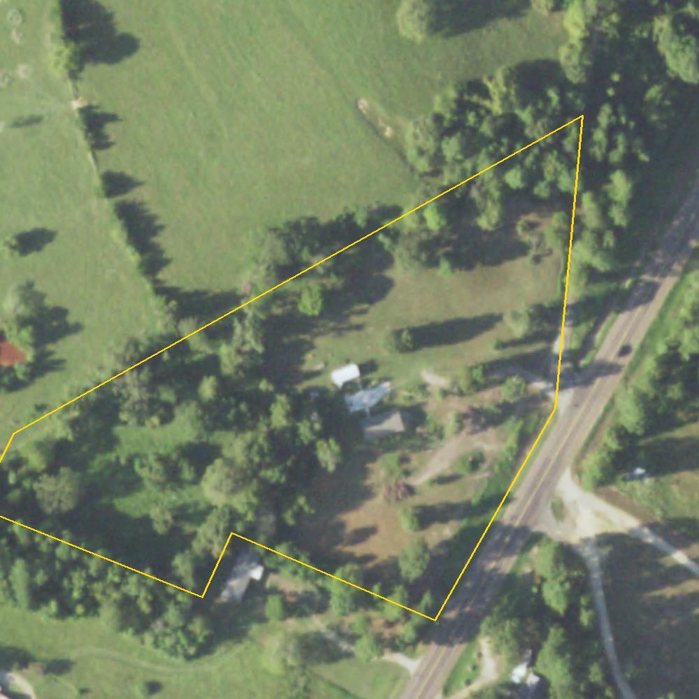
The aerial photographs fill in the rest. In 2009, and again in 2015, an older house with a brown roof stands among the trees near the middle of the lot, with a red-roofed shed and a white metal building close by. In the photograph of 2016 the house is gone and the ground where it stood has been cleared. The white building is still standing in the photographs of 2018 and 2022.17
The Next Chapter
In 2017 a new home was set on the cleared ground, close to where the old house had stood.18 It sits on 5.488 acres where County Road 3199 meets Highway 7.10 That is about one two-hundred-seventieth part of the third of a league that a young surveyor chose in 1835 and never lived to see measured.
- The land
- 5.488 acres, Tract 22 of the Pennington Sydney Survey, Abstract 555, Shelby County
- Granted
- 1835 order of survey; 1838 certificate No. 167; surveyed April 15, 1838; patented to the heirs July 3, 1847
- The home
- 2 bedrooms · 2 baths · 1,856 sq ft · placed 201718
- Around it
- Joaquin, 1 mile north · the Sabine River, about 3 miles east · Logansport, La., 3.3 miles
The pines that carried Penington's initials stood at the corners of his 1,476 acres; no one can say now which trees they were. The river still runs three miles to the east, where the Neutral Ground began. The story of this land began before Texas was Texas, and its next chapter has not been written yet.
A Timeline
- 1806 The Neutral Ground agreement, November 5.
- 1810, 1812 Joint expeditions drive outlaws from the strip.
- 1821 The Adams-Onís Treaty takes effect; the Sabine becomes the border.
- 1834 Sydney O. Penington comes to Texas.
- 1835 September 1: George W. Smyth's order to survey Penington's third of a league. December: the siege of Bexar.
- 1836 March: Penington and Smyth sign the Texas Declaration of Independence. Shelby County is created.
- 1837 Penington serves in the Republic's Congress until June, and dies in October.
- 1838 March 14: certificate No. 167 at Shelbyville. April 15: Thomas S. McKee surveys the land and marks its trees S.O.P.
- 1839–41 The county's first map shows Watson's Ferry and Haley's Ferry on the Sabine.
- 1840 James and Sarah Truitt settle about five miles away. Charles W. Jackson shoots Joseph Goodbread at Shelbyville.
- 1841 May 22: Watson's power of attorney for the patent. October: the McFaddens are tried at Shelbyville.
- 1844 The battle at Church Hill; Houston sends the militia on August 15; the factions disband.
- 1847 July 3: the patent to Penington's heirs, Abstract 555.
- 1866 The county seat moves from Shelbyville to Center.
- 1884 B. F. Morris gives the railroad its right-of-way; Joaquin is laid out.
- 1886 Joaquin's post office opens.
- 1914 Joaquin has a sawmill, a bank, a gin, a mill and the Plaindealer.
- 1958 The government's map shows a house on this lot.
- 1969 The map is revised; a second building appears.
- 2015 The old house still stands in the aerial photograph.
- 2016 The house is gone; the ground is cleared.
- 2017 A new home is placed on the land.
- Today The next chapter begins.
Where This Comes From
- Cecil Harper Jr., “Shelby County,” Handbook of Texas Online, Texas State Historical Association: the Caddo, El Camino Real, the twenty-league rule and the county's “reputation for violence,” Tenehaw and Nashville, the railroad of 1885, and the Red-Lander's report on land prices.
- J. Villasana Haggard, “Neutral Ground,” Handbook of Texas Online; National Park Service, “Neutral Strip in Louisiana Territory.”
- J. Edward Townes, “Neutral Strip,” 64 Parishes, Louisiana Endowment for the Humanities: the people of the strip, the merchants' complaints, and the 1810 and 1812 expeditions.
- “The Fearless Fifty-Nine: Sydney O. Penington,” Washington on the Brazos State Historic Site: his arrival in 1834, surveying in Shelby County, age, military service, Congress, death in October 1837, the 1936 monument, and the disputed spelling.
- Texas General Land Office, Land Grant Record, Shelby County Abstract 555, file 220, original grantee Sydney Pennington, patentee Sydney O. Pennington (heirs), 1,476.12 acres, patent No. 392, vol. 5, dated July 3, 1847, certificate 233; and the scanned file itself: the order of survey (San Augustine, September 1, 1835), certificate No. 167 (Shelbyville, March 14, 1838), Thomas S. McKee's field notes (April 15, 1838, certified November 9, 1840), and William Watson's power of attorney (May 22, 1841). Readings of the handwriting are ours.
- Texas General Land Office, “Headright and Military Land Grants”: a First Class headright gave a single man who was in Texas before March 2, 1836, one-third of a league, about 1,476 acres.
- Texas State Cemetery, “William Carroll Crawford”: Crawford and Sydney O. Penington represented Shelby County at the Convention of 1836 at Washington-on-the-Brazos and signed the Declaration of Independence.
- Robert Wooster, “Smyth, George Washington,” Handbook of Texas Online: land commissioner at Nacogdoches in 1835, delegate for Jasper, signer of the Declaration.
- W. Stafford, Map of Shelby County, 1839–1841, Texas General Land Office map 4032: Watson's Ferry and Haley's Ferry among its features.
- Shelby County Appraisal District record for property 14597, 1208 CR 3199, tax year 2026 (legal description and acreage), via the Texas Geographic Information Office's StratMap Land Parcels, read October 28, 2026.
- Gilbert M. Cuthbertson, “Regulator-Moderator War,” Handbook of Texas Online: every event of Chapter IV, and Sam Houston's remark as quoted there.
- Texas Historical Commission markers: Site of Truitt Community (2002) and Truitt Cemetery (1974). Distances measured from the markers' recorded positions.
- Cecil Harper Jr., “Truitt, James,” Handbook of Texas Online.
- Texas Historical Commission marker, B. F. Morris and the Town of Joaquin (1977).
- Cecil Harper Jr., “Joaquin, TX,” Handbook of Texas Online.
- U.S. Geological Survey historical topographic maps, via The National Map: Center, Tex.–La. (1958; photorevised 1969) and Logansport West, La.–Tex. (1984; 2003). Petty Creek from USGS Geographic Names. Public domain.
- Aerial photographs of 2009, 2015, 2016, 2018 and 2022 from the Texas Geographic Information Office imagery services (Texas Orthoimagery Program; USDA National Agriculture Imagery Program).
- The home's description from its real estate listing, read October 24, 2026.
Compiled October 28, 2026 from public records, government maps and photographs, and the archive of the Texas General Land Office. Every fact carries its source above.